When I left this morning Carol took a picture of me sitting on the bike and I thought that I’d post it here, but unfortunately the image turned out to be of some old guy with a horrible grimace on his face. In the next few days I’ll try to find a young and good-looking guy to wear my jacket and sit on the bike and I’ll post that picture.
As is usual these posts will contain many details about route numbers, meals, temperatures, and road conditions that won’t be of interest to anyone but me. The posts serve as a memory bank of my rides.
After a bit of last minute packing and searching for various items I left the house under cool and slightly foggy skies - typical San Francisco July weather. My first stop was just down the road at Orchard Supply and Hardware where I searched in vain for a pocket 4 in 1 screwdriver. Fortunately, the next OSH 20 miles on had what I wanted. The next stop was at the San Carlos REI where I picked up a couple of micro fiber towels, very useful for cleaning my helmet faceshield without scratching the plastic. Errands complete I continued south on 101 to Gilroy where I went west on 152 and stopped after 15 miles at Casa de Fruta for lunch. Casa de Fruta is a sprawling complex with a gas station, restaurant, cafe, fruit stands and a conference center and has been there for over 100 years, although presumably it was much smaller when it started. Back on 152 I rode over Pacheco Pass by the San Luis Reservoir and then south on I-5. It was about 65 in San Francisco when I left, 75 in San Jose and Gilroy, and 85 once in the central valley although it gradually warmed. The I-5 Interstate through the valley is flat, hot, and boring except for the frequent signs supporting the farmers and ranchers in the ongoing water wars. South of Coalinga the GPS directed me east on farm roads to US 99 where I went south to Delano where I’m spending the night. The temperature stayed between 90 and 95 for the last couple of hours, which is bearable as long as I’m moving. Tomorrow it is supposed to be 115 in Blythe where I’m spending the night. (274 miles)
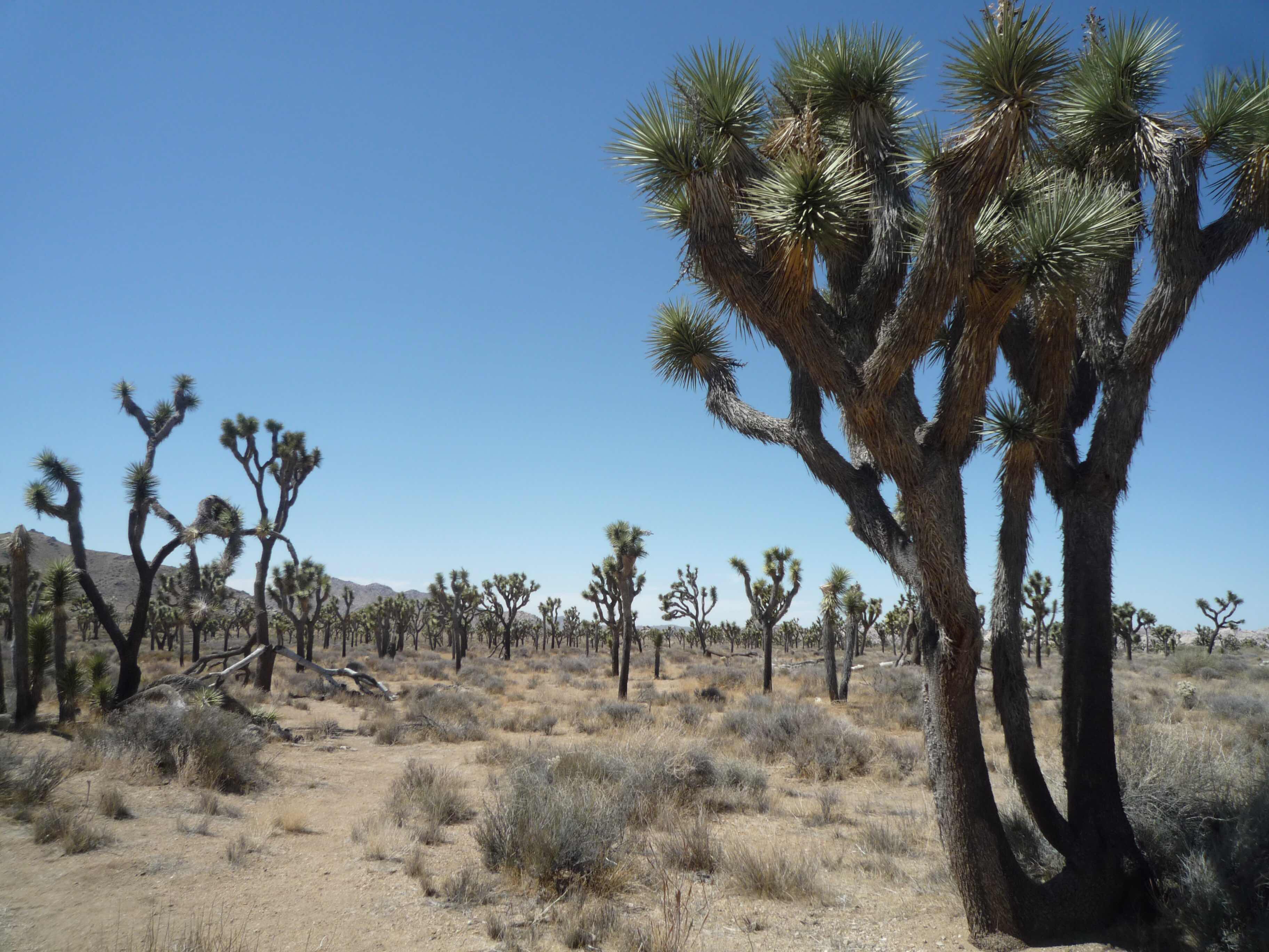
(Thursday, July 5) After coffee and waffles at the motel I rode south on Highway 99 through sprawling Bakersfield (pop. over 300,000) and I have to say that 99 doesn’t show the town at its best, but then perhaps that is as good as it gets. Bakersfield is best known as the birthplace of Merle Haggard and for the first two lines of the Rolling Stones song “Far Away Eyes”: I was driving home early Sunday morning through Bakersfield/Listening to gospel music... After another 30 miles I stopped in Tehachapi where I had a ham and cheese croissant and coffee at Kohnen’s Bakery. Highway 58 goes through the Tehachapi mountains (highest elevation 4300 feet) and the temperature was a pleasant 80-85 until the elevation dropped and the temperature rose to the mid 90’s. At Kramer Junction I went south on US 395 to Adelanto and Victorville, where I went on CA 18 through the towns of Apple Valley and Lucerne Valley, which despite their pleasant names are nondescript and dusty desert towns in the Yucca Valley. In Lucerne Valley I went on CA 247 for 40 miles to CA 62 (Twenty-nine Palms Highway) to the town of Joshua Tree, where the singer Gram Parsons died of an overdose at the Joshua Tree Inn back in 1973. Two of his friends (by prior arrangement) kidnapped Gram’s body and cremated it in Joshua Tree National Park at Cap Rock on the road to Keys View. I stopped at a cafe at the visitor’s center for an espresso and a mango smoothie, and rode into the park. The road is well-maintained but, as with most National Parks, the speed limit is very conservative, but on the other hand there wasn’t much traffic and few rangers. I turned off at Keys View, which used to be a gravel road until about 10 years ago, and at the viewpoint looked over the hazy valley to Indio and Palm Springs.

The elevation at Keys View is over 5000 feet and the temperature was only 95, but back on Pinto Basin road heading south and out of the park the elevation went down and the temperature went up.
Joshua Trees are interesting plants, almost comical in the way the branches seem to be like arms. They are spread throughout the park, as are formations of large rocks with fanciful names like Hall Of Horrors and Skull Rock.

As I went south towards the park exit and I-10 the temperature rose to over 100 degrees, reaching 114.8 at one point. I-10 is an unpleasant slog with heavy truck traffic and quite a few cars and trucks alongside the road with overheated engines or blown tires. I’m spending the night in Blythe, right at the Arizona border. It was 113 degrees when I walked to a Mexican restaurant for dinner, and I don’t care how dry it is, that is hot. (388 miles)
(Friday, July 6) When I walked out of the motel room this morning at about 6:30 to get coffee in the lobby, the heat hit me - it hadn’t cooled off overnight. The motel breakfast was quite good, and when I left the motel parking lot an hour later the thermometer on the bike showed 105 degrees.
Heading east on I-10 I entered Arizona after a few miles and then 30 miles later exited at Quartzite for gas (no vapor recovery nozzles for the rest of the trip until I return to California!) and to pick up US 60 which is a two-lane road with minimal traffic. It is also bleak, desolate, and dusty and there was a strong crosswind from the south. The few small towns on the road all have RV camps, although if I had an RV I’d look for a more scenic place. An hour later I was in Wickenburg and south of there I stopped at a convenient rest area to drink a quart of water and take a break. The temperature was holding at about 110, so not quite as hot as yesterday, but it was still early. After a few miles I turned east on US 74 which goes into north Phoenix. I was making a stop at the Hideaway Bar a Grill, a famous (in Harley circles) biker destination. There wasn’t much going on at noon on a Friday, but that evening they’d fire up the barbecue and the place would be jumping. Can you imagine standing over a huge barbeque grill in 110 degree heat, and certainly much hotter near the grill?

The lunch wasn’t all that great although everyone was very friendly and helpful when I asked for a recommendation for a good route to Springerville, where I’d booked a motel. The Hideaway is in Cave Creek which seems to be a manufactured town that is modeled on Virginia City in Nevada outside of Carson City. There’s a psychic place, several motorcycle oriented businesses, bars, souvenir shops, ice cream and coffee shops, and of course T-shirt stores.
All morning I’d admired the fields of cacti along the road but never bothered to take a picture. They are all over the place in Phoenix as well, and even one in the parking lot near the Hideaway.

I followed the directions of the friendly biker at the Hideaway and my GPS to wander around Phoenix a bit and get out of town. Phoenix is very spread out, but the new-looking neighborhoods I rode through seemed to follow a plan of minimal visual impact. All the houses and most of the other buildings are tan adobe that blend into the desert and I didn’t see any overhead power or cable/phone lines - everything must be underground. The various shopping malls have minimal signage and if you didn’t know a mall was there you could drive right by it.
Eventually I came to Fountain Hills and AZ 87, which goes north into the Tonto National Forest. The road is in good shape, four lanes wide, but not a road that I would normally favor. However, it was a very hot day, and I’d previously been on other more interesting roads through the forest, so 87 was OK. I stopped at the Piñon Cafe in Payson for coffee and a slice of pie - strawberry rhubarb. The sky clouded up and there was even a little sprinkle, but I didn’t bother with my rain gloves or rain pants. Over the next couple of hours I’d run into a few brief showers, and in Show Low it looked as though it had rained hard earlier - a couple of parking lots had very large puddles. The temperature jumped around a lot - 85 when the sun was out, 65 when it was cloudy and sprinkling. In Payson I’d picked up AZ 260 and in Show Low I went east on US 60, over a 7500 foot pass, and into Springerville where I’m spending the night at Reed’s Lodge, which is an old place and apparently very popular with motorcyclists.
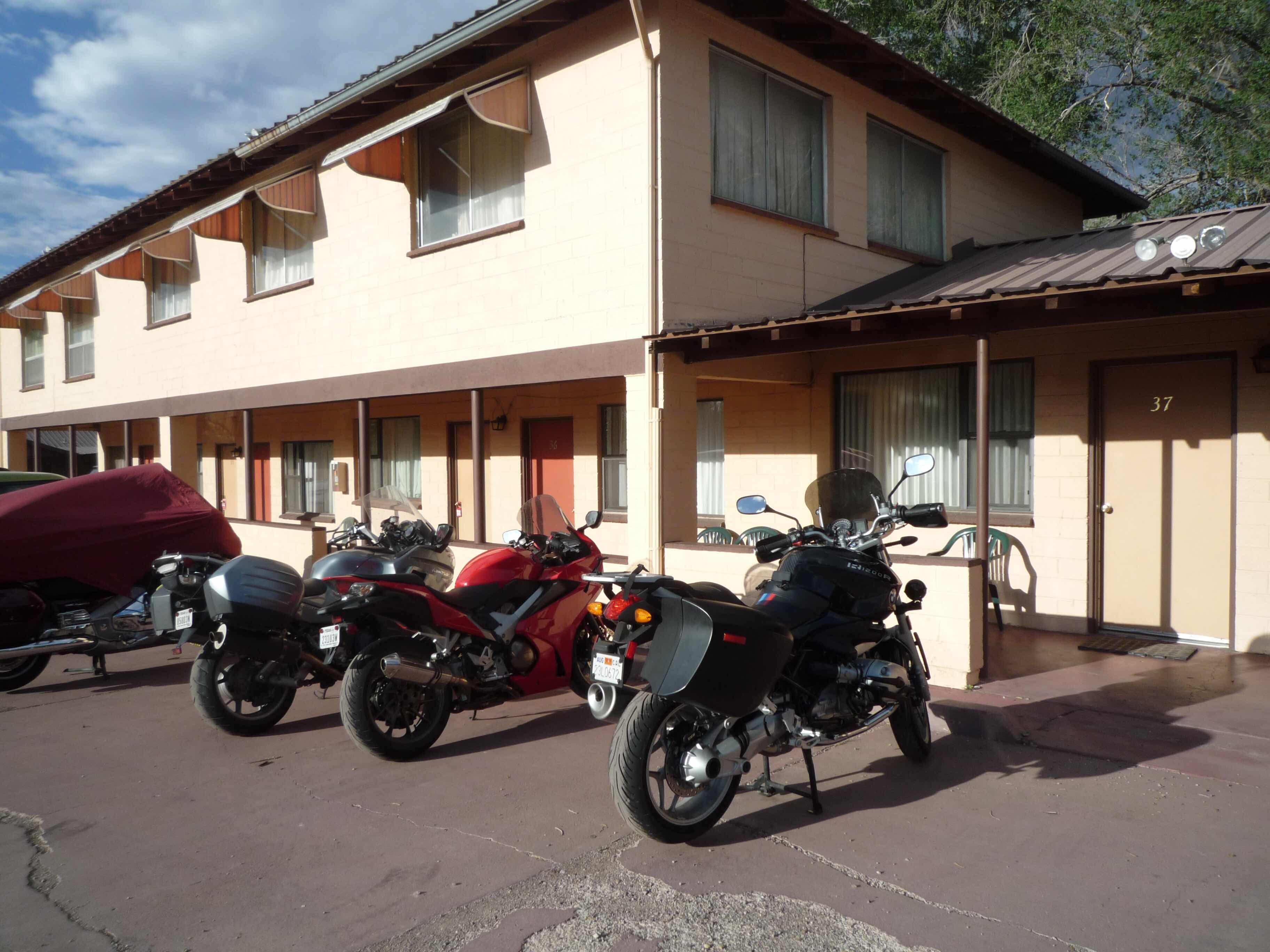
The lodge also has a large gift shop and bookstore both of which have a Native American and Western theme. The place also seems to be popular with families, and there are a lot of kids running around and also dogs. A good choice. (410 miles)
(Saturday, July 7) I skipped breakfast at the restaurant across the street from the lodge because I’ve been eating three large meals every day on this trip and that is too much. Besides, I needed to save room for pie in Pie Town. It was a beautiful, sunny morning with a few scattered clouds and after 13 miles on US 60 I entered New Mexico and lost an hour. This is high desert country with a few ranches, scattered forests, and no traffic. I stopped at the Pie Town Cafe and had a fried egg sandwich and a slice of apple pie, both of which were good. This is a smaller operation than the Pie-O-Neer across the highway and down the road a bit where I’d stopped last year - half a dozen tables, fewer pie choices, and a much smaller memorabilia section.

Although I’d planned to have another slice of pie at the Pie-O-Neer, it didn’t open until 11:30, another half hour, and since I’d already been there before I continued on US 60 across the Continental Divide (8000 feet) until I came to the VLA (Very Large Array) radio telescope site and I decided to stop at the visitors’ center since I hadn’t made the second stop in Pie Town. Apparently all the cars that weren’t on US 60 were at the VLA because the parking lot was full. The self-guided walking tour was interesting and the radio telescopes are impressive. Each of the 27 antennas in the array weighs over 230 tons and is 82 feet across and 90 feet high. They are situated on railroad tracks and can be moved within the complex to follow signals. Each antenna receiver is cryogenically cooled to -427F - only 18 degrees K. All in all an impressive site and worth a stop if you are ever in the area. The VLA, which was opened in 1980, is situated on the Plains of Augustin, which is surrounded by mountains that keep radio interference at a minimum and the altitude of 7500 feet also contributes to clear signals from space.


Back on US 60 I continued on a very pleasant ride through Magdalena (where I once spent the night) and into Socorro where I stopped for gas and met a couple from Cedar Rapids, Iowa on Harleys - both big twins, but with only windscreens and panniers. They were riding without helmets and in T-shirts and I hope they used plenty of sunscreen. South 10 miles on I-25 I turned off at San Antonio and went east on US 380. I went by the Owl’s Nest Bar and Grill, another well-known Harley spot but didn’t stop because I wasn’t hungry and after the Hideaway in Cave Creek I felt that I’d done my Harley bar thing for the trip. There were a half dozen Harleys parked in front as well as another dozen or so cars and pickups.
The weather had been holding at a very pleasant 85 degrees under a sunny sky but as I continued east it became very black in the distance and I saw a few lightning flashes. This is mostly dry country but afternoon thunderstorms are not uncommon this time of year. There were a few sprinkles and then suddenly the temperature dropped 20 degrees and it began to rain hard. When I finally found a good spot to pull over and make myself waterproof the rain stopped and the sun came out so I continued on. This would happen several times over the next couple of hours. US 380 goes through Carrizoza, Billie the Kid country, and the Capitan mountains and through the town of Capitan, home of the original Smoky the Bear, so the town has old west tourist places and Smoky exhibits.
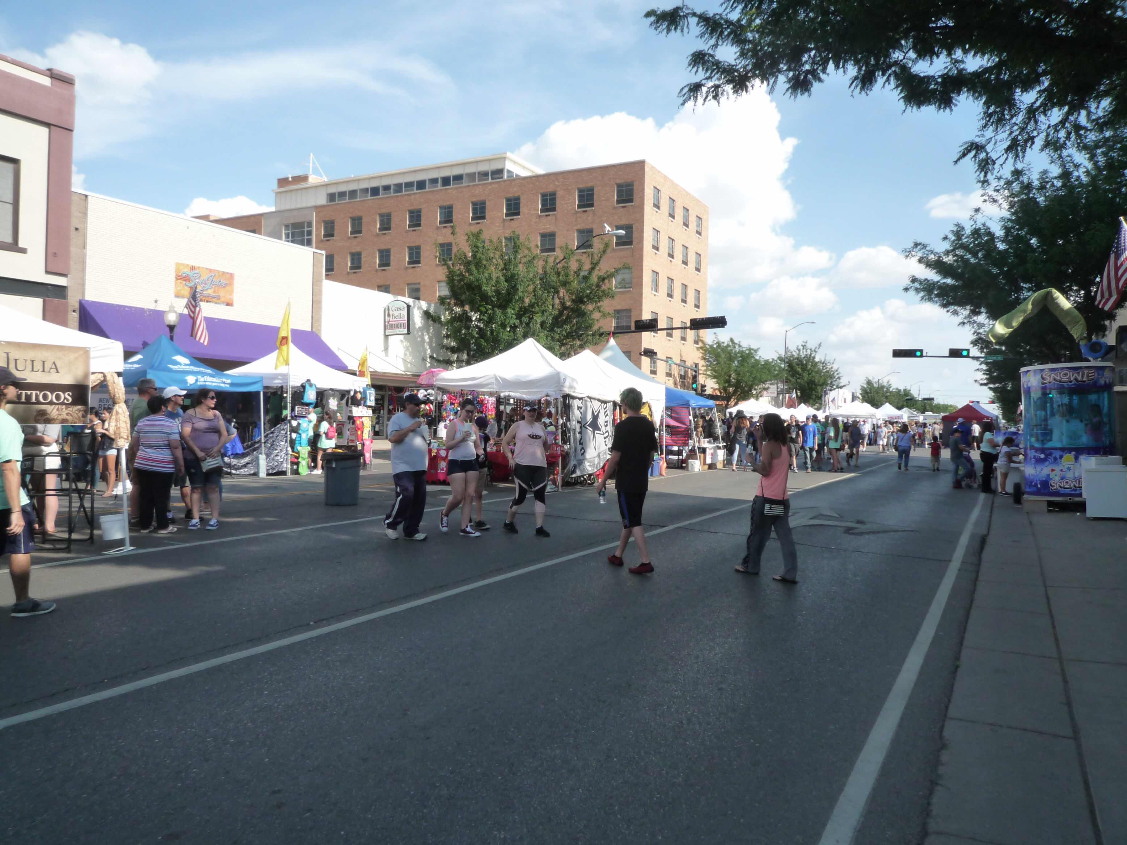
The elevation gradually got lower and I came into Roswell, famous as the (supposed) site of a UFO crash in 1947. (It was actually an Air Force weather balloon, but who believes the government.) Andrew and I stopped here back in 1999 and since then the town has tripled in size. I’d planned on a quick stop for coffee and to pick up some postcards at the UFO museum, but I found that this weekend is a three day Alien Con and two blocks of Main street were closed off for vendors, exhibits, music, and wandering people celebrating all things UFO and alien.

On the advice of a friendly worker at the UFO museum I went to Stellar Cafe where I had the best coffee of the trip so far and also met two older guys, friends who were in town for Alien Con, one from Tucson and one from outside Toronto. We traded stories about travels and the computer industry and I spent more time than I’d planned in Roswell so that by the time I left the skies ahead were looking very ominous. I soon ran into a very heavy storm with lightning on both sided of the road and a high crosswind that had me leaning the bike at a steep angle. Naturally there was no place to pull over and even if I had I’m not sure the bike would have stayed upright or if I could have put on my rain gear. My solution to the dilemma, in retrospect perhaps not the wisest choice, was to ride faster to get out of the storm as quickly as possible and sure enough after 10 minutes or so it stopped raining, the sky cleared, and I began to dry out.
In Tatum I turned south on NM 206 and after 20 miles came into Lovington (elevation 3500 feet) where I’m spending the night at the Lovington Inn. Neither the town nor the motel are impressive. The desk clerk said they’d had heavy rain in the morning and I’d noticed flooded fields and large puddles everywhere when I got near town. Tomorrow I get into Texas. (430 miles)
(Sunday, July 8) The Lovington Inn is a bit of a dump, but it was quiet and I slept well, and the breakfast at Dusty’s restaurant that came with the room was OK and the coffee was good. Based on the weather forecast and my wet experience yesterday I wore my waterproof overpants and rain gloves when I started out this morning. I rode on NM 18 out of Lovington to Hobbs, NM and went east on US 180, which I would follow for the rest of the day. It is an old four-lane road through west Texas for thirty miles and then becomes two-lane for most of the rest of the way. The speed limit is a generous 75 mph - in fact it would remain at 75 outside the towns until I got near the more populated areas closer to Dallas. The land is flat with a few oil wells, some ranches and small farms, and a lot of empty space covered in dry grass and low trees or bushes. There was very little traffic on a Sunday morning. The only thing I saw worthy of a picture was an old, restored Sinclair gas station in Snyder.

I stopped for lunch at Hatahoe Chick and Fish in Anson north of Abilene and had an interesting conversation with Nick, who was there with his mom. I often travel with another rider, but one of the benefits of traveling alone is that you are more approachable, and people feel more comfortable initiating a conversation. While Nick and I were talking, a huge rainstorm blew through. It lasted about 20 minutes and by the time I left the temperature was back up to 85 degrees and it was sunny. To me it looked like the end of days and I was ready to hide under the table, but everyone else in the place just looked outside, and said, “Oh, it’s raining.” Nick’s mom asked if it was hailing, and when told that it wasn’t she nodded dismissively and went back to her meal. Unfortunately, I caught up with the tail end of the storm after about 20 minutes. It had mostly moved to the south and the sky in that direction was completely black with bolts of lightning every 5 seconds or so. There was also a heavy crosswind which lasted for about 10 minutes, but after that the sky cleared and the temperature went up to a muggy 90-95.
The farther east I went the closer the small towns were together. Albany has an old fashioned courthouse square complete with an impressive stone courthouse, but other than that the towns were small and undistinguished. I began to see cars and trucks towing boat trailers as I neared Hubbard Creek Reservoir - families returning from a weekend on the lake. I found the Heritage Inn in Weatherford with no problem, but it’s a rather run down establishment in spite of its impressive name. However, the lone washing machine was unoccupied so I did a laundry.
One of the rules of motorcycling is to never begin a long trip with untested equipment, and I’d never before used the large duffle bag that was a gift from John C. It has a large central compartment with a waterproof lining, but the side pockets are not waterproof, a fact that I discovered when I retrieved the maps that I’d stored inside. Tomorrow after the moto museum I’ll stop at an AAA office in Dallas to replace a few of the maps, and at a Target or grocery store to pick up some plastic bags. (352 miles)
No comments:
Post a Comment